Other Experience

Conferences

2026 Esri Developer & Technology Summit Attendee

Dates
March 10–13, 2026
Location
Palm Springs, CA
Role
Attendee
Attended as
TRC (Esri Platinum Partner)

Glenn attended the 2026 Esri Developer & Technology Summit, focusing on the ArcGIS Maps SDK for JavaScript, the ArcGIS API for Python, imagery, and GeoAI. Highlights included building AI assistants with the Maps SDK for JavaScript, app development with web components, GeoAI with imagery and 3D data, managing and analyzing cloud imagery with Python, and real-time analytics with ArcGIS Velocity. Glenn also discovered the summit’s annual dodgeball tournament, but by the time he learned about it, the tournament was already full. Sign up early if you go!

Sessions attended (16)

  • Developer & Technology Summit Plenary Session: Day 1
  • Developer & Technology Summit Plenary Session: Day 2
  • Developer & Technology Summit Keynote
  • ArcGIS Maps SDK for JavaScript: Building AI Assistants
  • ArcGIS Maps SDK for JavaScript: App Development with Components, Part 1: Programming Patterns
  • GeoAI with Imagery and 3D Data
  • ArcGIS: An Overview of 3D Capabilities
  • ArcGIS Velocity: An Overview
  • ArcGIS Maps SDKs for Native Apps: An Overview and What's New
  • ArcGIS API for Python: Working with ArcGIS Apps
  • ArcGIS: Advanced Image Analysis of Imagery Stored in the Cloud
  • ArcGIS API for Python: Managing Imagery Layers
  • ArcGIS Maps SDK for JavaScript: Working with Imagery
  • ArcGIS Living Atlas of the World: Automating Analysis with Imagery Content Using Python
  • ArcGIS Velocity: Customizing and Configuring Real-Time Data Feeds and Analytics
  • ArcGIS Maps SDK for JavaScript: Build Your First App

Photos

Certificates

2025 Esri User Conference Attendee

Dates
July 14–18, 2025
Location
San Diego, CA
Role
Attendee
Attended as
TRC

Glenn attended the 2025 Esri User Conference with a focus on imagery, remote sensing, and GeoAI. His sessions covered drone and reality mapping workflows from capture to insight, image management and analysis at scale, multidimensional change and trend analysis, pretrained deep learning models for feature extraction, and Python automation with ArcPy and the ArcGIS API for Python. Glenn also won a free Trimble Catalyst DA2 GNSS receiver and connected with GIS professionals from around the world, including New Zealand, Austria, Pakistan, Saudi Arabia, the United Kingdom, and Canada, as well as Texas, Alaska, California, Oregon, Ohio, Florida, and Colorado.

Sessions attended (17)

  • ArcGIS Maps SDK for JavaScript: Programming Patterns and Best Practices
  • Introduction to Reality Mapping with Drone, Aerial, and Satellite Imagery
  • Drone Reality Mapping: A Complete Workflow from Capture to Insights
  • Reality Mapping at Scale: Citywide and Countrywide Mapping
  • ArcGIS Enterprise and Online: Image Management at Scale
  • Imagery: Change, Trend, and Pattern Analysis Using Multidimensional Data
  • ArcGIS: Managing and Visualizing Oriented Imagery
  • ArcGIS Pro: Python Map Automation Beyond the Basics
  • ArcGIS: Getting Started with GeoAI
  • GeoAI in Practice
  • ArcGIS Maps SDK for JavaScript: Tips and Tricks for Developing and Debugging Apps
  • Best Practices for Capturing Drone Imagery
  • ArcGIS: An Overview of Image Analysis
  • ArcPy and ArcGIS API for Python: Raster Analysis
  • ArcGIS Image Analyst: Tips and Tricks
  • ArcGIS Online: Processing and Analyzing Imagery
  • ArcGIS: Using Pretrained Deep Learning Models for Feature Extraction and Classification

Photos

Certificates

2018 Esri User Conference Attendee

Dates
July 9–13, 2018
Location
San Diego, CA
Role
Attendee
Attended as
Tetra Tech, Inc.

Glenn attended the 2018 Esri User Conference while working as an Environmental Scientist and Project Manager at Tetra Tech, connecting with the GIS community and exploring new ArcGIS capabilities for environmental and emergency response work.

2016 Michigan Bridge Conference Presenter

Event
Michigan Department of Transportation (MDOT) Michigan Bridge Conference
Date
March 23, 2016
Location
Lansing, MI
Role
Presenter, with the Michigan Tech Research Institute (MTRI) development team
Presented on
Server and Database Implementation

Glenn’s role: Glenn was a supporting developer on 3DBridgE. He led the implementation and development of the backend and database configuration using Python, Django, PostgreSQL, and pgAdmin III. He built the Django web application that queried and managed data from the PostgreSQL database, handled user input, and returned bridge data as XML over HTTP to the 3D application. At the 2016 Michigan Bridge Conference, Glenn presented on the Server and Database Implementation of 3DBridgE.

How 3DBridgE works

  1. The old way: paper forms. Inspectors recorded element-level data by hand on paper forms under the bridge, then re-entered it back at the office.

  2. Server and database (Glenn's presentation). 3D models didn't exist for most bridges, so the server builds one. It queries MDOT's bridge management database, derives missing scales and quantities, assembles a generic bridge model, applies user tuning, and sends the finished model to the app as XML.

  3. Load a bridge. The inspector picks a bridge and downloads its XML model to the tablet.

  4. Explore the 3D model. The bridge renders in 3D, and the inspector navigates it by dragging and pinching.

  5. Record a defect. Defects are placed right on the model with their element, type, severity, size, and description.

  6. View it from any angle. The compass and view controls let inspectors check each defect from multiple perspectives.

  7. Attach photos and comments. Field photos and notes are linked to the exact defect location.

  8. Review the summary. Defects roll up by condition (Good, Fair, Poor, Severe) and element.

  9. Generate the element report. Quantities are compiled into AASHTO element-level report format.

  10. Beyond the deck. The same workflow covers substructure elements like abutments.

Organizations

Women in GIS (WiGIS) Professional Member

Joined March 2025 (current)

Glenn is a professional member of Women in GIS, a nonprofit community that supports and connects women and allies working in the geospatial field. Glenn is a huge feminist and was lucky enough to get a membership to Women in GIS through TRC. (Thank you, TRC!)

Wyoming Geospatial Organization (WYGEO) Community Member

Joined 2021

Glenn is a community member of the Wyoming Geospatial Organization. He joined in 2021 while living in Laramie, Wyoming, where he lived for two years.

OSGeo (Open Source Geospatial Foundation) Community Member

Joined 2021

Glenn is a community member volunteer for OSGeo, the open source geospatial community, which lets him contribute to OSGeo’s content.

Minnesota GIS/LIS Consortium Community Member

Joined 2021

Glenn is a community member of the Minnesota GIS/LIS Consortium. He joined after a colleague on a project, who lived in Minnesota and was a member, recommended the organization.

Scientific Coalition for UAP Studies (SCU) Community Member

Joined December 2023 (current)

Glenn is a community member volunteer for the SCU, a nonprofit dedicated to the scientific study of unidentified anomalous phenomena (UAP).

Resume

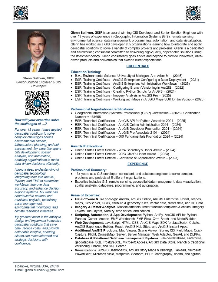
First page of Glenn Sullivan's resume

Please explore this website to learn more about Glenn's experience. His resume was last updated on November 20, 2025, and Glenn is aiming to update it in early 2027 with WSP branding as he's excited for his new role at WSP!

Letters of Recommendation

Here are two letters of recommendation Glenn has received.

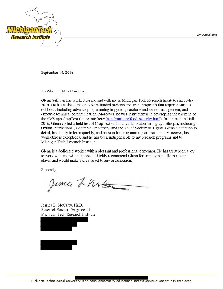
First page of the letter of recommendation from Jessica L. McCarty, Ph.D.

Jessica L. McCarty, Ph.D.

Research Scientist/Engineer II

Michigan Tech Research Institute

September 14, 2016

View letter β†—
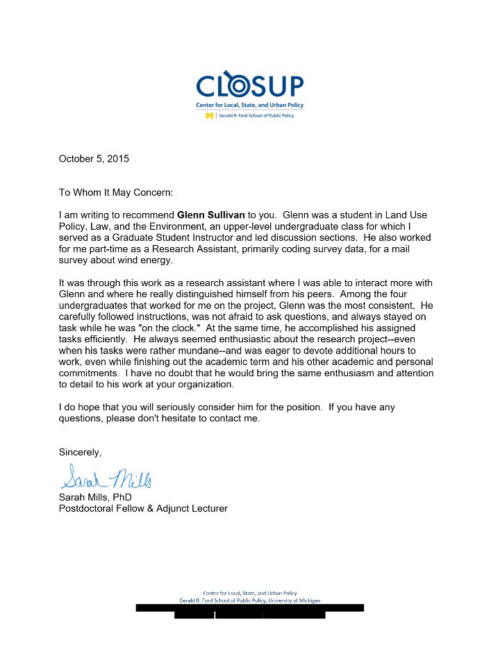
First page of the letter of recommendation from Sarah Mills, PhD

Sarah Mills, PhD

Postdoctoral Fellow & Adjunct Lecturer

University of Michigan, Gerald R. Ford School of Public Policy

October 5, 2015

View letter β†—